
GPS Trackers for Municipal Fleets: Enhancing Public Service Accountability
Across cities and towns, municipal fleets are expected to deliver more than just services—they're expected to perform with speed, accuracy, and transparency. Whether it’s a snow plow clearing roads after a storm or a utility truck responding to an outage, public expectations have shifted. Citizens want to know that the job will get done, but when, how efficiently, and where their tax dollars go. That pressure has placed local governments in a position where traditional fleet management tools simply aren’t enough.
This is where digital transformation comes in. One of the most impactful upgrades in modern municipal operations is adopting GPS fleet tracking. For local governments asking what GPS fleet tracking is, the answer is simple: it’s a system that uses GPS technology to monitor the real-time location, behavior, and performance of every vehicle in a public fleet. But it’s more than just dots on a map—it’s a tool for smarter planning, proactive decision-making, and improved public accountability.
The benefits of GPS in city fleet operations are wide-ranging. With live data, fleet managers can reroute snow plows based on changing weather, verify service delivery in disputed areas, or pinpoint inefficient driving behavior that drives fuel costs. From routine garbage collection to emergency services, GPS tracking gives municipalities the insight they need to respond faster, manage costs better, and build trust with their communities.
What is GPS Fleet Tracking and Why Does It Matter for Municipal Services
Municipal services operate on tight schedules, limited budgets, and growing public scrutiny. Whether snow plows clear streets, sanitation trucks collect waste, or utility vehicles respond to service requests, every vehicle’s movement must be accounted for. This is where GPS fleet tracking becomes essential.
So, what is GPS fleet tracking? In simple terms, it’s a system that uses Global Positioning System (GPS) technology to monitor and record vehicles' location, movement, and behavior in real time. These systems collect data from GPS-enabled devices installed on vehicles and relay the information to centralized software dashboards. City administrators and fleet managers can use this data to oversee operations, improve response times, and make informed decisions.
Historically, city fleets relied on paper logs, manual check-ins, or radio dispatches to track service vehicles. These methods left room for error, delay, and a lack of visibility. If a citizen called to ask when their street would be plowed or trash picked up, staff had limited answers unless they could radio the driver. Modern GPS solutions eliminate this gap by offering real time GPS monitoring of every asset, accessible from a single platform.
It's important to address a common misconception: GPS fleet tracking is not about surveillance or micromanagement. Instead, it’s a tool for smart management and accountability. The goal isn’t to watch every driver's move—it’s to ensure that city services are running smoothly, vehicles are being used efficiently, and public resources are protected.
Among the most notable advantages of vehicle tracking is the ability to verify service delivery. When a complaint arises, such as a missed garbage pickup or a snowplow delay, administrators can review location data to determine exactly when and where a vehicle was. This transparency builds public trust and resolves issues faster.
Core Municipal Applications: How GPS Works Across City Fleets
City and town fleets handle essential services, from sanitation and snow removal to utility repairs and park maintenance. Managing these operations efficiently requires more than just dispatch schedules and paper logs—it demands accurate, real-time insights into vehicle location, usage, and route status. That’s where GPS fleet tracking becomes indispensable, providing municipalities with the tools to increase service reliability, reduce waste, and respond more effectively to public needs.
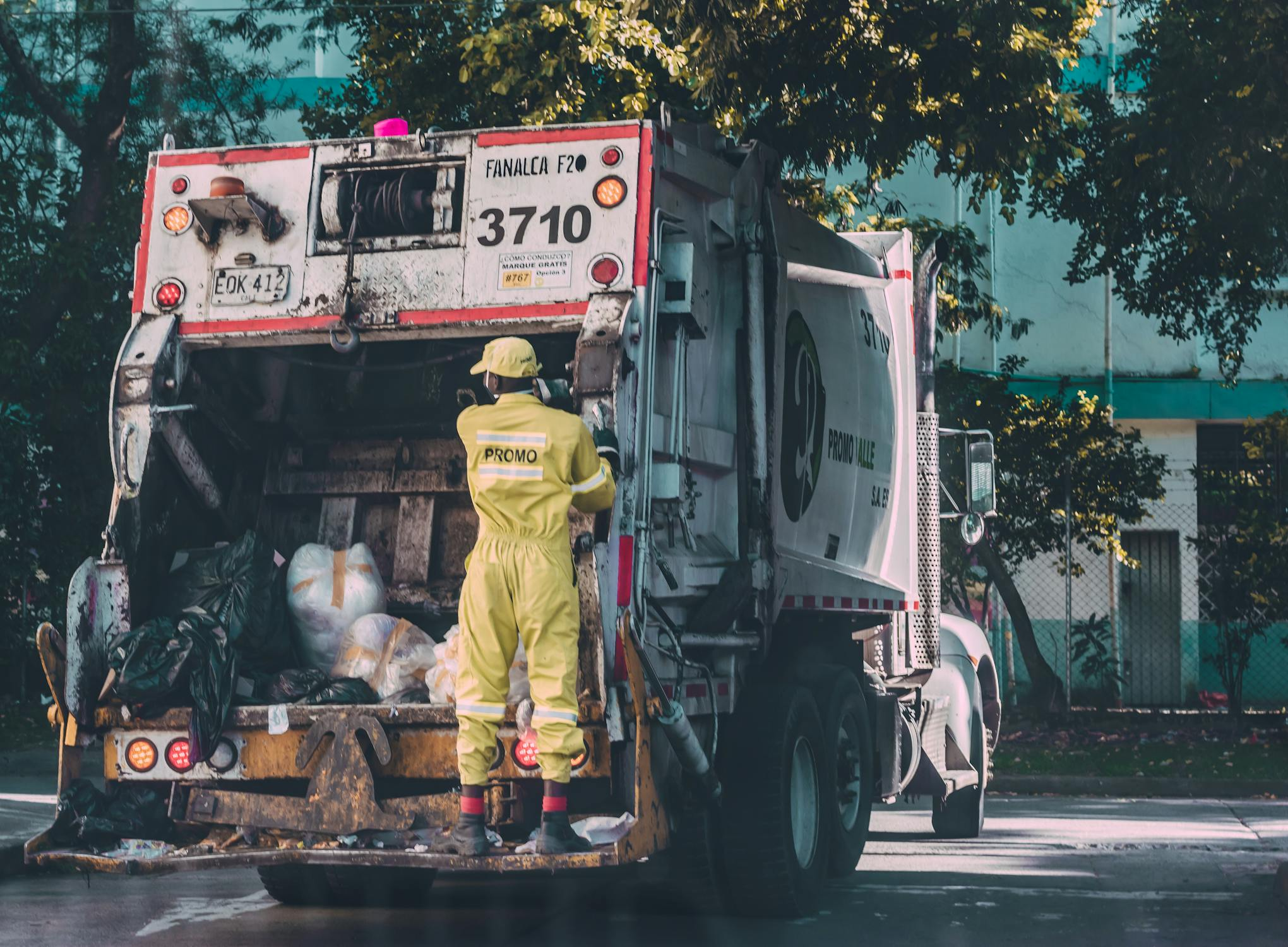
Sanitation Services
Garbage and recycling trucks follow strict schedules in busy areas. With real-time vehicle tracking, supervisors can monitor routes to ensure nothing is missed. If a pickup is reported as skipped, they can check the route history for confirmation. GPS fleet tracking route optimization helps reduce fuel costs and overtime by identifying better routes. Some cities even share service logs with residents to boost transparency.
Snow Plow Tracking
In winter, geofencing vehicle tracking helps manage snow removal. Plows are monitored as they enter or exit virtual zones around key roads, helping verify coverage and plan redeployment. Real-time tracking allows for quick response to weather changes or urgent needs. Some municipalities offer public maps showing recently cleared streets.
Utility and Water Fleets
Utility vehicles respond to outages, leaks, and repairs. GPS tracking improves dispatch and shows route history for job verification. Route optimization ensures fast response during widespread issues and supports better scheduling across large service areas.
Parks & Recreation Vehicles
For tasks like mowing and tree trimming, GPS tracking ensures vehicles stay within park limits and prevents off-hours use. Geofencing alerts staff to unexpected movement, while usage logs help refine fleet size, maintenance, and staffing.
The Accountability Equation: Transparency, Trust, and Data Access

In today’s connected world, municipalities are expected to deliver services efficiently—and to prove it. GPS tracking offers a reliable, data-backed way to build transparency, foster public trust, and maintain internal accountability. GPS technology becomes more than a monitoring tool for cities and towns managing fleets of garbage trucks, snow plows, utility vehicles, and maintenance crews. It becomes a GPS solution for better governance.
Public-facing dashboards are a key component of this transformation. Municipalities can clearly communicate when services have been delivered by sharing real-time or near-real-time data with citizens. For example, many cities now offer snow plow tracking maps that allow residents to see which streets have been cleared and when. These visual tools eliminate ambiguity, reduce complaints, and build community trust.
The benefits of GPS tracking extend beyond visibility. GPS data creates a verifiable audit trail that helps city officials resolve service complaints accurately. If a resident claims their recycling wasn’t picked up, fleet managers can review historical GPS data to confirm whether the truck visited that location at the scheduled time. This helps teams avoid unnecessary rework and addresses complaints with evidence-based responses.
Internally, the advantages of GPS are just as powerful. Data collected from vehicle movement, stop durations, and route history can be compiled into reports demonstrating operational performance. City councils and oversight committees can use this data to assess productivity, evaluate service coverage, and determine budget alignment. Rather than relying on manual reports or anecdotal feedback, decision-makers gain access to a comprehensive digital footprint of daily fleet activity.
This kind of data access also supports long-term planning. Departments can identify inefficiencies, adjust routes, or allocate resources more effectively—all from insights provided by their GPS systems. With a scalable GPS solution, municipalities can track trends over time, compare seasonal patterns, and support future infrastructure or service expansion investments.
Ultimately, accountability is not just about keeping track of vehicles—it's about giving residents, staff, and elected officials confidence that services are being delivered as promised. That’s where the benefits of GPS tracking truly shine: in making public service delivery more transparent, dependable, and efficient.
Key Benefits of GPS Tracking for Municipal Fleet Management
Running a municipal fleet without accurate, real-time data is like navigating a city without street signs. GPS tracking changes that. For local governments looking to improve service delivery while staying accountable to taxpayers, the benefits of GPS tracking go far beyond just knowing where vehicles are—they reach deep into cost savings, driver safety, and asset protection.
Smarter Fuel Use and Cost Control
Fuel is a major expense for municipal fleets, especially for vehicles like snow plows, utility trucks, and garbage collectors. GPS tracking helps reduce waste by flagging excessive idling and inefficient routes. Real-time route data and idle reports allow fleet managers to enforce smarter driving practices and cut unnecessary fuel use. Over time, these savings add up across the entire fleet, helping municipalities stay within budget without compromising coverage.
Safer Driving Through Monitoring
Municipal vehicles often operate in sensitive areas like school zones and neighborhoods, making safe driving essential. GPS platforms monitor speeding, harsh braking, and aggressive turns. This data helps supervisors coach drivers and address risky habits early. By promoting safe driving, fleets can reduce accident risk, lower insurance costs, and improve public trust.
Preventative Maintenance and Vehicle Longevity
Unplanned breakdowns disrupt essential services. GPS systems automate maintenance alerts using engine hours, mileage, and performance data. This allows municipalities to schedule repairs before issues arise, extend vehicle life, and avoid downtime that impacts snow removal or emergency response.
Equipment Security with Tracking and Geofencing
Municipal equipment is vulnerable to theft, especially in unsecured lots or remote areas. Asset tracking devices allow managers to monitor the location of trailers, generators, and service trucks in real time. With geofencing vehicle tracking, virtual boundaries can be set around job sites or depots. If a vehicle leaves its assigned area unexpectedly, the system sends an immediate alert, enabling fast action and improving the odds of recovery.
These tools offer municipalities a powerful combination of security and accountability, helping them safeguard public assets while demonstrating responsible stewardship.
Route Optimization: A Real-Time Revolution in City Logistics
Managing municipal fleets—for garbage collection, snow removal, or utility services—requires precision and adaptability. Yet, traditional route planning methods often fail to address real-world variables like traffic congestion, road closures, weather disruptions, and emergency calls. That’s where GPS fleet tracking route optimization comes into play. For city departments under pressure to do more with less, it’s a game-changer.
At the heart of modern fleet tracker systems is the real-time adjustment of routes. This isn't just about plotting a path from point A to point B—it's about ensuring the route remains efficient throughout the day. Let’s say a snow plow is assigned to clear a residential area, but a sudden storm reroutes traffic or closes off a bridge. The driver may proceed without updates with traditional methods, wasting fuel and time. But with GPS-enabled systems, dispatchers are alerted to the change and can instantly send updated routing to the vehicle, keeping operations smooth and on schedule.
This level of agility is powered by real time vehicle tracking. Unlike older systems that rely on periodic updates or static plans, real-time monitoring continuously feeds vehicle location, direction, speed, and stop data. This allows city planners and fleet supervisors to respond instantly to disruptions—rerouting vehicles around traffic jams, utility work, or accidents—without compromising service delivery.
The benefits extend beyond logistics. Municipalities see measurable reductions in fuel consumption and vehicle wear by optimizing routes. When trucks avoid unnecessary mileage, cities save money while reducing environmental impact. Many departments report a 10–20% improvement in fuel efficiency after implementing GPS fleet tracking.
Whether you oversee sanitation trucks or storm response vehicles, adopting fleet tracker systems equipped with real-time routing tools isn’t just a tech upgrade. It’s a strategic investment in operational efficiency, public safety, and accountability. Cities that embrace GPS fleet tracking route optimization gain a powerful edge: the ability to serve faster, waste less, and adapt instantly to whatever comes their way.
In a world where time, fuel, and trust are valuable public resources, real time vehicle tracking offers municipalities the tools to manage them all more effectively.
Choosing a GPS Fleet Tracking System for Your Municipality
Selecting the right GPS solution for a municipal fleet is crucial to improving service delivery, optimizing resources, and meeting public accountability standards. Unlike commercial operations, cities and towns must consider performance and cost-efficiency, integration with public-facing systems, and regulatory requirements. Suppose you’re in the process of choosing a GPS fleet tracking system. In that case, evaluating a solution that aligns with your operational goals and supports the unique complexity of municipal logistics is essential.
What Features Should City Departments Look For?
Real-time tracking is at the core of any effective GPS solution, but that’s just the beginning. Municipal departments should look for features like geofencing to monitor service zones, customizable alerts for speeding or unauthorized use, and detailed reporting tools to support internal reviews or respond to citizen complaints. Compatibility with multiple vehicle types—from utility trucks to street sweepers—is another key consideration. A scalable fleet tracker system should support future growth, such as adding electric vehicles or seasonal equipment.
Wired vs. Battery-Powered Trackers
When choosing a GPS fleet tracking system, you must decide between wired and battery-powered units. Wired trackers are permanently installed and powered by the vehicle, making them ideal for daily-use municipal vehicles like garbage trucks or snow plows. They offer consistent data flow and often come with advanced diagnostics. Battery-powered trackers, however, are perfect for temporary or seasonal use, such as monitoring trailers or portable equipment during events or emergencies. A balanced mix of both gives municipalities flexibility across fleet types.
Integration with Municipal Systems
Efficiency improves dramatically when GPS data integrates with existing municipal software platforms. Whether syncing with 311 service request systems, GIS mapping software, or work order management tools, integration allows for a seamless data flow between departments. For example, if a resident reports a missed trash pickup through the city’s portal, GPS timestamps and location data can verify whether the truck serviced that address. This transparency improves service outcomes and reduces administrative overhead.
The Role of Compliance Support
Municipal fleets often cross jurisdictions, requiring careful documentation for fuel usage and driving hours. Choosing a GPS fleet tracking system with built-in support for ELD (Electronic Logging Devices) and IFTA (International Fuel Tax Agreement) reporting can simplify compliance, avoid fines, and reduce manual paperwork. A reliable GPS solution should provide automated mileage reports, engine hour tracking, and historical route logs—tools supporting compliance and audit readiness.
Ultimately, the best fleet tracker systems meet your city's real-world challenges with flexibility, accuracy, and accountability. With the right GPS solution, municipalities can deliver more innovative services, gain public trust, and confidently manage their assets.
Why Municipalities Trust Tracker Systems for Fleet Management
Cities and towns across the country are turning to Tracker Systems for reliable, long-term fleet tracker systems that perform under pressure. From harsh winter conditions to round-the-clock utility work, municipal fleets operate in challenging environments, and Tracker Systems builds GPS solutions that rise to meet them.
With years of experience supporting public works, sanitation, emergency services, and transportation departments, Tracker Systems understands local governments' unique operational demands. Their devices are designed for rugged municipal applications, offering water-resistant, dustproof hardware with IP-rated protection. These units deliver consistent data and performance, whether installed in snow plows, garbage trucks, or utility vans.
Tracker Systems' GPS solution suite includes features specifically designed for municipalities. These include:
- Geofencing for ensuring vehicles stay within designated service zones
- Real-time vehicle tracking to monitor location, speed, and stop durations
- Temperature alerts for vehicles carrying sensitive materials like chemicals or medical supplies
- Idle tracking and maintenance reminders to improve fleet longevity and fuel efficiency
What sets Tracker Systems apart is not just the hardware, but the support. Their team works closely with municipal IT and operations departments, helping with onboarding, training, and compliance reporting. This hands-on approach makes them a trusted partner when choosing a GPS fleet tracking system that aligns with public-sector accountability and efficiency goals.
If your city is exploring GPS-based fleet management, Tracker Systems is ready to help. Contact them for a free consultation or schedule a live demo to see how their technology can support your team and your community.
Final Thoughts: Accountability in Action with GPS Technology
GPS tracking has become an essential tool for modern municipal fleet management. From improving response times and optimizing routes to preventing equipment misuse and supporting public transparency, the benefits of GPS tracking extend across every department, whether it's sanitation, utilities, or snow removal. Cities and towns that embrace this technology save time and money and build greater trust with the communities they serve.
It's important to remember that GPS tracking is not about surveillance—it's about delivering smarter, more reliable public services. When used properly, the advantages of GPS vehicle tracking systems include increased efficiency, better accountability, and safer operations for drivers and the public alike.
If you're ready to elevate your city’s fleet performance, contact Tracker Systems today for a demo or personalized consultation.
Recent Posts
-

How to Choose Between a standalone GPS tracker and a GPS phone app
You’re trying to track something important, and the options feel deceptively simple. Do you buy a de …Jan 23rd 2026 -

The Pros and Cons of GPS Trackers with Real-Time Tracking
Real-time tracking in vehicle and asset monitoring means the location of a car, truck, or piece of e …Jan 16th 2026 -

Using GPS Trackers to Monitor Employee Performance
Field teams, drivers, and mobile crews are often the face of your business. They meet customers, del …Jan 5th 2026